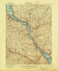
1912 Map of Mc Calls Ferry
USGS Topo · Published 1948About this map
The Susquehanna River cuts a deep, winding path between Lancaster and York counties in this 1910 survey, illustrating a landscape defined by water power and industrial transition. The Holtwood Power Plant stands as a massive modern anchor near the southern end of the sheet, contrasted by the quiet remnants of the Susquehanna and Tidewater Canal (Abandoned) lining the river's edge. This era captures the height of the river-and-rail economy, with the Columbia and Port Deposit RR hugging the shoreline opposite the Pennsylvania RR.
Find a feature on this map
131 named features on this map. Tap any name to fly to it.
Don’t see what you’re looking for? This feature index may not catch every label — zoom into the map to look around manually.
Map Details
Editions of this 1912 Mc Calls Ferry Map
5 editions found

Other maps of this area

1900 · Havre De Grace
USGS Topo · 1:62,500

1900 · Parkton
USGS Topo · 1:62,500

1901 · Belair
USGS Topo · 1:62,500

1902 · Parkton
USGS Topo · 1:62,500

1902 · Lancaster
USGS Topo · 1:62,500

1904 · Lancaster
USGS Topo · 1:62,500

1906 · New Holland
USGS Topo · 1:62,500

1908 · Middletown
USGS Topo · 1:62,500

1908 · New Holland
USGS Topo · 1:62,500

1908 · York
USGS Topo · 1:62,500
Featured Places
- West Lampeter Township, PA
- Willow Street, West Lampeter Township
- Millersville, PA
- Pequea, Conestoga Township
- Conestoga Township, PA