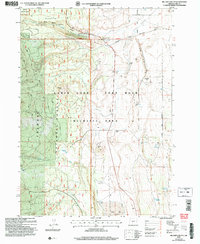
2004 Map of Mc Carty Butte
USGS Topo · Published 2007About this map
Wastina sits as a quiet historical marker in this high-desert landscape, where the transition from the dense woodlands of Fremont National Forest to the open basin of the Cabin Lake - Fort Rock Wildlife Area is clearly defined. The terrain is marked by significant volcanic and geological features like McCarty Butte and the rising edge of the Rim near Dunham Hill. Water management is central to this arid environment, evidenced by scattered improvements such as McCallum Well and a series of livestock-supporting impoundments including Mattis Reservoir, Lasater Reservoir, and Schumacher Reservoir. The northern section is dominated by the Deschutes National Forest boundary and the historic Fifth Standard Parallel South, reflecting early survey efforts that organized this portion of the Oregon outback. The presence of Horse Ranch and the Christmas Valley Byway suggests the enduring ranching and transportation corridors that define this region.
Find a feature on this map
27 named features on this map. Tap any name to fly to it.
Don’t see what you’re looking for? This feature index may not catch every label — zoom into the map to look around manually.
Map Details
Editions of this 2004 Mc Carty Butte Map
This is the sole edition of this map. No revisions or reprints were ever made.
Other maps of this area

1955 · Crescent
USGS Topo · 1:250,000

1957 · Crescent
USGS Topo · 1:250,000

1958 · Crescent
USGS Topo · 1:250,000

1968 · Silver Lake
USGS Topo · 1:24,000

1968 · Oatman Flat
USGS Topo · 1:24,000
1968 · Antelope Mtn
USGS Topo · 1:24,000

1970 · Crescent
USGS Topo · 1:250,000

1979 · Crescent
USGS Topo · 1:100,000
1981 · Wickiup Spring
USGS Topo · 1:24,000
1981 · Fort Rock
USGS Topo · 1:24,000