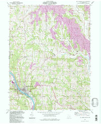
1994 Map of Mc Connelsville
USGS Topo · Published 1998About this map
The Muskingum River flows past the riverfront communities of Mc Connelsville and Malta in this mid-1990s survey of Morgan County. The landscape is a study in industrial transition, where numerous Gas Wells and Oil Wells dot the hillsides alongside extensive tracts marked as Reclaimed Area and Reclaimed Strip Mine. This period captures the recovery of the terrain following significant resource extraction, while preserving the traditional rural infrastructure of small settlements like Slemmons and Neelysville.
Find a feature on this map
41 named features on this map. Tap any name to fly to it.
Don’t see what you’re looking for? This feature index may not catch every label — zoom into the map to look around manually.
Map Details
Editions of this 1994 Mc Connelsville Map
This is the sole edition of this map. No revisions or reprints were ever made.
Other maps of this area

1909 · Caldwell
USGS Topo · 1:62,500

1910 · Philo
USGS Topo · 1:62,500

1910 · Mc Connelsville
USGS Topo · 1:62,500

1911 · Cumberland
USGS Topo · 1:62,500

1912 · Caldwell
USGS Topo · 1:62,500

1949 · Clarksburg
USGS Topo · 1:250,000

1956 · Clarksburg
USGS Topo · 1:250,000

1961 · Clarksburg
USGS Topo · 1:250,000
1961 · Beverly
USGS Topo · 1:24,000

1961 · Mc Connelsville
USGS Topo · 1:24,000