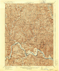
1909 Map of Caldwell
USGS Topo · Published 1956About this map
The Muskingum River flows through the southwestern corner of this survey, defining the industrial and transport corridor between Beverly and Waterford. At the turn of the twentieth century, this region across Morgan, Noble, and Washington counties was a dense network of rural school districts and hilltop churches. The rugged geography is marked by distinctive elevations like Old Tom Ridge and Coffee Knob, while the Marietta Branch Pennsylvania System provides a rail link through Caldwell and Olive. Unique local place names such as Beancatcher School and Poochville School reflect the vernacular history of the small townships. Traces of early land divisions are visible through the Ohio Company Purchase boundary and the North Relief Boundary, indicating the systematic settlement patterns that shaped this portion of southeast Ohio long after the initial frontier era.
Find a feature on this map
129 named features on this map. Tap any name to fly to it.
Don’t see what you’re looking for? This feature index may not catch every label — zoom into the map to look around manually.
Map Details
Editions of this 1909 Caldwell Map
This is the sole edition of this map. No revisions or reprints were ever made.