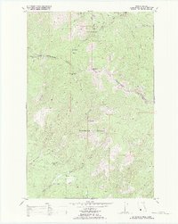
1989 Map of Mc Cormick Peak
USGS Topo · Published 1989About this map
The Reservation Divide serves as the prominent physical and administrative backbone of this mountain landscape, marking the high-altitude boundary between the Flathead Indian Reservation to the north and the Lolo National Forest to the south. This boundary also aligns with the county line between Sanders and Missoula Counties, tracing a series of high points including Mc Cormick Peak, Blackrock Peak, and Josephine Peak. The map reveals a history of resource extraction tucked into the steep drainages, specifically within Favorite Mine Gulch, where the Favorite Mine and associated Tailings indicate localized mining activity. The drainage patterns are well-defined, with the headwaters of Revais Creek and its various forks flowing north, while Mc Cormick Creek and Butler Creek drain the southern slopes. Several Pack Trails provide the primary access through this remote terrain, connecting the high basins like Blacktail Basin to the valley bottoms.
Find a feature on this map
24 named features on this map. Tap any name to fly to it.
Don’t see what you’re looking for? This feature index may not catch every label — zoom into the map to look around manually.
Map Details
Editions of this 1989 Mc Cormick Peak Map
This is the sole edition of this map. No revisions or reprints were ever made.
Other maps of this area

1956 · Wallace
USGS Topo · 1:250,000

1959 · Tarkio
USGS Topo · 1:62,500

1959 · Alberton
USGS Topo · 1:62,500

1959 · Perma
USGS Topo · 1:62,500

1960 · Wallace
USGS Topo · 1:250,000

1964 · Dixon
USGS Topo · 1:24,000

1964 · Mc Donald
USGS Topo · 1:24,000
1983 · Stark South
USGS Topo · 1:24,000

1984 · Stark North
USGS Topo · 1:24,000
1984 · Huson
USGS Topo · 1:24,000