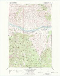
1988 Map of Mc Donald
USGS Topo · Published 1988About this map
The Flathead River flows through the heart of the Flathead Indian Reservation in this 1988 update of Sanders County. This area shows a landscape defined by its water and industrial infrastructure, where the Northern Pacific railroad tracks parallel the river's northern bank near the settlement of Mc Donald. To the south, the topography rises sharply toward the peak of Son-yok Mtn, drained by a series of steep drainages including Magpie Creek, Gunderson Creek, and Revais Creek. A notable intersection of industry and geography is visible at the Green Mountain Mine, situated deep in the southern reaches of the quadrangle. The map also documents essential irrigation and utility corridors, such as the Revais Canal and a prominent pipeline, which support the agricultural life of local holdings like Melton Ranch.
Find a feature on this map
17 named features on this map. Tap any name to fly to it.
Don’t see what you’re looking for? This feature index may not catch every label — zoom into the map to look around manually.
Map Details
Editions of this 1988 Mc Donald Map
This is the sole edition of this map. No revisions or reprints were ever made.
Other maps of this area

1956 · Wallace
USGS Topo · 1:250,000

1959 · Tarkio
USGS Topo · 1:62,500

1959 · Alberton
USGS Topo · 1:62,500

1959 · Perma
USGS Topo · 1:62,500

1960 · Wallace
USGS Topo · 1:250,000

1964 · Dixon
USGS Topo · 1:24,000

1964 · Mc Donald
USGS Topo · 1:24,000

1964 · Melton Ranch
USGS Topo · 1:24,000

1965 · Sloan
USGS Topo · 1:24,000

1984 · Stark North
USGS Topo · 1:24,000