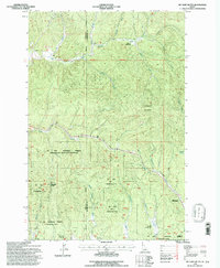
1994 Map of Mc Gary Butte
USGS Topo · Published 1997About this map
Jackson Mountain and the prominent Mc Gary Butte anchor this section of the St Joe National Forest along the border of Latah and Clearwater counties. The landscape is defined by the upper reaches of the Potlatch River and its numerous tributaries, including Bloom Creek and Jackson Creek. Evidence of industrial history is woven into the terrain, most notably the Old RR Grade that winds through the hills and the Neva Tunnel located near the eastern boundary. Several high-elevation clearings, such as Bloom Meadows, Oviatt Meadows, and Round Meadows, dot the forest, while the small settlement of Kameron sits in the southeastern corner. This map documents a transitional period in forest management and infrastructure, showing the relationship between historic logging transportation and contemporary resource sites like the Gravel Pit and Electronic Site.
Find a feature on this map
32 named features on this map. Tap any name to fly to it.
Don’t see what you’re looking for? This feature index may not catch every label — zoom into the map to look around manually.
Map Details
Editions of this 1994 Mc Gary Butte Map
This is the sole edition of this map. No revisions or reprints were ever made.
Other maps of this area

1955 · Pullman
USGS Topo · 1:250,000

1958 · Pullman
USGS Topo · 1:250,000

1961 · Ahsahka
USGS Topo · 1:62,500

1961 · Bovill
USGS Topo · 1:62,500

1969 · Elk River
USGS Topo · 1:24,000

1969 · Elk Creek Falls
USGS Topo · 1:24,000

1969 · Anthony Peak
USGS Topo · 1:24,000

1981 · Potlatch
USGS Topo · 1:100,000
1990 · Bechtel Butte
USGS Topo · 1:24,000
1990 · Mc Gary Butte
USGS Topo · 1:24,000