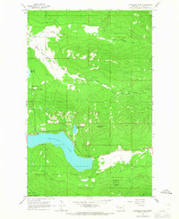
1964 Map of Mc Gregor Peak
USGS Topo · Published 1967About this map
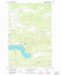
McGregor Lake serves as a dominant focal point in this northwestern Montana landscape, where the waters of Little McGregor Lake and the Fisher River define the local drainage. In the mid-1960s, the area reflects a balance between timber-industry infrastructure and early recreational development, visible through the presence of Boisvert Camp and Paradise Lodge along the shoreline. The terrain rises sharply toward McGregor Peak, while the open flats of Lost Prairie are bisected by the Lower Lost Prairie Road. Much of the territory is managed within the Kootenai National Forest and Lolo National Forest, with a network of corridors like the Pack Trail and KNF Trail providing access to the higher elevations and drainage systems of Bear Springs Creek.
Find a feature on this map
18 named features on this map. Tap any name to fly to it.
Don’t see what you’re looking for? This feature index may not catch every label — zoom into the map to look around manually.
Map Details
Editions of this 1964 Mc Gregor Peak Map
2 editions found
Other maps of this area

1956 · Wallace
USGS Topo · 1:250,000

1957 · Kalispell
USGS Topo · 1:250,000

1960 · Kalispell
USGS Topo · 1:250,000

1960 · Wallace
USGS Topo · 1:250,000

1961 · Kalispell
USGS Topo · 1:250,000

1964 · Meadow Peak
USGS Topo · 1:24,000
1964 · Pleasant Valley Mountain
USGS Topo · 1:24,000

1964 · Hubbart Reservoir
USGS Topo · 1:24,000
1964 · Shroder Creek
USGS Topo · 1:24,000

1964 · Murr Peak
USGS Topo · 1:24,000