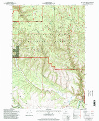
1995 Map of Mc Intyre Creek
USGS Topo · Published 1998About this map
Starkey Experimental Forest anchors the southwestern portion of this landscape, where the confluence of Starkey Creek and Meadow Creek marks a significant drainage junction near the Meadow Cow Camp. The terrain is defined by the complex convergence of three distinct forest boundaries, with the Umatilla National Forest and Wallowa-Whitman National Forest meeting at the Umatilla and Union county line. This 1990s-era study documents a highly dissected plateau characterized by named drainages like Dark Canyon and Winter Canyon, which feed toward the Grande Ronde River in the southeast. Numerous developed water sources, including Antler Spring, Coyote Spring, and Porter Spring, indicate the historical importance of water management for timber and livestock across these high-altitude forest lands.
Find a feature on this map
27 named features on this map. Tap any name to fly to it.
Don’t see what you’re looking for? This feature index may not catch every label — zoom into the map to look around manually.
Map Details
Editions of this 1995 Mc Intyre Creek Map
This is the sole edition of this map. No revisions or reprints were ever made.
Other maps of this area

1953 · Pendleton
USGS Topo · 1:250,000

1956 · Pendleton
USGS Topo · 1:250,000

1963 · Meacham Lake
USGS Topo · 1:24,000

1964 · Mc Intyre Creek
USGS Topo · 1:24,000

1964 · Huron
USGS Topo · 1:24,000

1964 · Kamela SE
USGS Topo · 1:24,000

1965 · Marley Creek
USGS Topo · 1:24,000

1965 · Little Beaver Creek
USGS Topo · 1:24,000
1967 · Bassey Creek
USGS Topo · 1:24,000

1967 · Sullivan Gulch
USGS Topo · 1:24,000