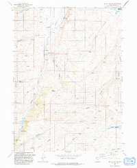
1991 Map of Mc Kay Hollow
USGS Topo · Published 1991About this map
Saleratus Reservoir No 1, along with its numbered counterparts and the larger Neponset Reservoir, define the water management strategy of this high-elevation landscape in Rich County. The terrain is a complex system of drainage and storage, where Saleratus Creek and Crane Creek are fed by numerous named sources like Negro Dan Spring and Chicken Spring. The land is deeply incised by drainages such as McKay Hollow and Kate Hollow, which separate prominent landforms like Table Mountain and McKay Ridge. Within the southern portion of the quadrangle, a segment of the Cache National Forest is visible, reflecting the transition between public grazing or resource land and more specialized water infrastructure. The presence of Drill Holes and a distributed Pipeline network suggests active resource extraction and water transport systems integrated into the rural geography of the early 1990s.
Find a feature on this map
30 named features on this map. Tap any name to fly to it.
Don’t see what you’re looking for? This feature index may not catch every label — zoom into the map to look around manually.
Map Details
Editions of this 1991 Mc Kay Hollow Map
This is the sole edition of this map. No revisions or reprints were ever made.
Other maps of this area

1954 · Ogden
USGS Topo · 1:250,000

1958 · Ogden
USGS Topo · 1:250,000

1960 · Ogden
USGS Topo · 1:250,000

1964 · Francis Canyon
USGS Topo · 1:24,000

1968 · Wahsatch
USGS Topo · 1:24,000

1968 · Shearing Corral
USGS Topo · 1:24,000

1968 · Mc Kay Hollow
USGS Topo · 1:24,000

1968 · Neponset Reservoir NE
USGS Topo · 1:24,000

1968 · Meachum Ridge
USGS Topo · 1:24,000

1968 · Peck Canyon
USGS Topo · 1:24,000