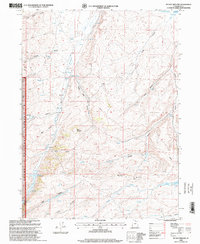
1998 Map of Mc Kay Hollow
USGS Topo · Published 2001About this map
Neponset Reservoir anchors the northern reaches of this high-elevation landscape in Rich County, where water management is central to the land's utility. The drainage system is dominated by the seasonal paths of Saleratus Creek and Crane Creek, punctuated by a series of impoundments including Saleratus Reservoir No 1, No 2, and No 3. This network of reservoirs and a prominent Pipeline suggest a landscape heavily engineered for livestock or irrigation in an otherwise arid environment. Along the western edge, the Cache National Forest boundary introduces a transition from open grazing land to the more complex topography of Five Canyon and Spring Canyon. Significant landmarks such as Table Mountain and McKay Ridge provide natural orientation points amidst a web of 4WD trails that navigate named drainages like Negro Dan Hollow and Alkali Hollow.
Find a feature on this map
31 named features on this map. Tap any name to fly to it.
Don’t see what you’re looking for? This feature index may not catch every label — zoom into the map to look around manually.
Map Details
Editions of this 1998 Mc Kay Hollow Map
This is the sole edition of this map. No revisions or reprints were ever made.
Other maps of this area

1954 · Ogden
USGS Topo · 1:250,000

1958 · Ogden
USGS Topo · 1:250,000

1960 · Ogden
USGS Topo · 1:250,000

1964 · Francis Canyon
USGS Topo · 1:24,000

1968 · Wahsatch
USGS Topo · 1:24,000

1968 · Shearing Corral
USGS Topo · 1:24,000

1968 · Mc Kay Hollow
USGS Topo · 1:24,000

1968 · Neponset Reservoir NE
USGS Topo · 1:24,000

1968 · Meachum Ridge
USGS Topo · 1:24,000

1968 · Peck Canyon
USGS Topo · 1:24,000