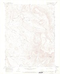
1964 Map of Mc Kenna Peak
USGS Topo · Published 1968About this map
Bassnet Homestead and Heidman Homestead offer evidence of the high-desert ranching and settlement patterns established in this corner of Colorado during the mid-20th century. The landscape is dominated by the Spring Creek Basin and the striking elevation of McKenna Peak, which rises above a series of draws and canyons. The San Miguel and Dolores County line cuts through the southern portion of the map, marked by the flow of Disappointment Creek and the notable Brumley Point. Water management and natural resources are indicated by features like Custer Dam, Wildcat Spring, and the Desert Claim Ditch. The network of Jeep Trails and the inclusion of a Gaging Sta on the creek reflect the era's land use for grazing and environmental monitoring.
Find a feature on this map
22 named features on this map. Tap any name to fly to it.
Don’t see what you’re looking for? This feature index may not catch every label — zoom into the map to look around manually.
Map Details
Editions of this 1964 Mc Kenna Peak Map
3 editions found

Other maps of this area

1916 · Paradox Valley
USGS Topo · 1:125,000

1922 · Paradox Valley
USGS Topo · 1:125,000

1948 · Gypsum Gap
USGS Topo · 1:24,000

1949 · Gypsum Gap
USGS Topo · 1:24,000

1956 · Cortez
USGS Topo · 1:250,000

1956 · Moab
USGS Topo · 1:250,000

1958 · Cortez
USGS Topo · 1:250,000

1959 · Cortez
USGS Topo · 1:250,000

1959 · Moab
USGS Topo · 1:250,000

1960 · Moab
USGS Topo · 1:250,000