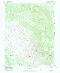
1964 Map of Mc Kenna Peak
USGS Topo · Published 1984About this map
Bassnet Homestead and Heldman Homestead anchor this mid-1960s landscape, reflecting the scattered ranching and agricultural efforts along the border of San Miguel and Dolores counties. The topography is dominated by the broad Spring Creek Basin and the prominent McKenna Peak, with the terrain falling away toward Disappointment Creek in the south. This area illustrates the critical importance of water management in a high-elevation arid environment, evidenced by the presence of Custer Ditch, Desert Claim Ditch, and Custer Dam. Navigation across the draws and canyons, such as Still Canyon and Wildcat Canyon, is facilitated by a network of unimproved routes, including the uniquely named The Butterfly trail. The presence of a Gaging Sta and multiple named springs suggests a landscape where every water source was essential for the survival of early settlements and livestock.
Find a feature on this map
27 named features on this map. Tap any name to fly to it.
Don’t see what you’re looking for? This feature index may not catch every label — zoom into the map to look around manually.
Map Details
Editions of this 1964 Mc Kenna Peak Map
3 editions found

Other maps of this area

1916 · Paradox Valley
USGS Topo · 1:125,000

1922 · Paradox Valley
USGS Topo · 1:125,000

1948 · Gypsum Gap
USGS Topo · 1:24,000

1949 · Gypsum Gap
USGS Topo · 1:24,000

1956 · Cortez
USGS Topo · 1:250,000

1956 · Moab
USGS Topo · 1:250,000

1958 · Cortez
USGS Topo · 1:250,000

1959 · Cortez
USGS Topo · 1:250,000

1959 · Moab
USGS Topo · 1:250,000

1960 · Moab
USGS Topo · 1:250,000