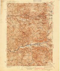
1940 Map of Mc Kenzie Bridge
USGS Topo · Published 1940About this map
Mc Kenzie Bridge and the Middle Santiam River valley form the backbone of this pre-war survey of the central Cascades. The map reveals a landscape defined by seasonal camps and industrial extraction, featuring the Lucky Boy Mine and Cinderella Mine tucked into the steep slopes near Blue River. Historically significant resorts like Belknap Springs and Foley Springs appear as developed nodes along the McKenzie Highway, providing a window into early Oregon mountain tourism and recreation.
Find a feature on this map
204 named features on this map. Tap any name to fly to it.
Don’t see what you’re looking for? This feature index may not catch every label — zoom into the map to look around manually.
Map Details
Editions of this 1940 Mc Kenzie Bridge Map
3 editions found

Other maps of this area

1925 · Waldo Lake
USGS Topo · 1:125,000

1927 · Mt. Jefferson
USGS Topo · 1:125,000

1929 · Mill City
USGS Topo · 1:125,000

1929 · Three Sisters
USGS Topo · 1:125,000

1930 · Maiden Peak
USGS Topo · 1:125,000

1930 · Mt. Jefferson
USGS Topo · 1:125,000

1932 · Three Sisters
USGS Topo · 1:125,000

1934 · Maiden Peak
USGS Topo · 1:125,000

1934 · Mc Kenzie Bridge
USGS Topo · 1:96,000

1935 · Lowell
USGS Topo · 1:96,000