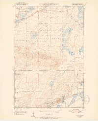
1951 Map of Mc Kinley
USGS Topo · Published 1951About this map
The iron-rich Mesabi Range landscape dominates this mid-century survey, defined by the heavy industry of the Duluth Missabe and Iron Range railroad and massive excavations. Significant mining operations like the Corsica Mine and extensive mine dumps sit adjacent to established worker settlements including McKinley, Elcor, and Franklin. The southern portion of the map is a complex network of city boundaries and rail lines, while the north transitions into the protected wilderness of the Superior National Forest. Local landmarks of communal life appear amidst the industrial activity, such as the Town Hall and the Florenton Cem. Natural features like Pike Mountain and the Pike River provide a stark topographical contrast to the neighboring open-pit disturbances, illustrating the era's intensive resource extraction and its effect on the St. Louis County terrain.
Find a feature on this map
30 named features on this map. Tap any name to fly to it.
Don’t see what you’re looking for? This feature index may not catch every label — zoom into the map to look around manually.
Map Details
Editions of this 1951 Mc Kinley Map
2 editions found
Other maps of this area

1950 · Biwabik
USGS Topo · 1:24,000

1950 · Mc Kinley
USGS Topo · 1:24,000

1950 · Biwabik NW
USGS Topo · 1:24,000

1950 · Biwabik NE
USGS Topo · 1:24,000

1951 · Biwabik
USGS Topo · 1:24,000

1951 · Mc Kinley
USGS Topo · 1:24,000

1951 · Biwabik NE
USGS Topo · 1:24,000

1951 · Biwabik NW
USGS Topo · 1:24,000

1951 · Palo
USGS Topo · 1:24,000

1951 · Gilbert
USGS Topo · 1:24,000