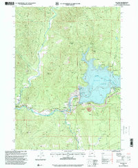
1997 Map of Mc Leod
USGS Topo · Published 2000About this map
Lost Creek Lake and its surrounding public lands dominate this landscape along the Rogue River, reflecting the late-twentieth-century transformation of the upper river canyon. The impoundment behind the William L Jess Dam is flanked by recreation areas like Joseph Stewart State Park and Takelma Park, while the infrastructure supporting the reservoir is clearly detailed, including the substation, powerhouse, and intake tower.
Find a feature on this map
34 named features on this map. Tap any name to fly to it.
Don’t see what you’re looking for? This feature index may not catch every label — zoom into the map to look around manually.
Map Details
Editions of this 1997 Mc Leod Map
This is the sole edition of this map. No revisions or reprints were ever made.
Other maps of this area

1891 · Ashland
USGS Topo · 1:250,000

1893 · Ashland
USGS Topo · 1:250,000

1897 · Ashland
USGS Topo · 1:250,000

1943 · Trail
USGS Topo · 1:62,500

1944 · Tiller
USGS Topo · 1:62,500

1944 · Abbott Butte
USGS Topo · 1:62,500

1947 · Abbott Butte
USGS Topo · 1:62,500

1954 · Butte Falls
USGS Topo · 1:62,500

1955 · Medford
USGS Topo · 1:250,000

1957 · Medford
USGS Topo · 1:250,000