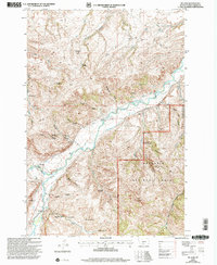
2000 Map of Mc Leod
USGS Topo · Published 2005About this map
Mc Leod serves as the focal point of this Sweet Grass County landscape, where the Boulder River carves through a terrain defined by deep draws and gulches. The settlement pattern here is deeply rooted in early 20th-century land claims, as evidenced by numerous named sites such as the Wagner Homestead, Sanford Homestead, and Dutton Homestead. These labels, preserved on the map alongside the Dutton School, reflect the homesteading era's legacy in Montana's ranching country.
Find a feature on this map
47 named features on this map. Tap any name to fly to it.
Don’t see what you’re looking for? This feature index may not catch every label — zoom into the map to look around manually.
Map Details
Editions of this 2000 Mc Leod Map
This is the sole edition of this map. No revisions or reprints were ever made.
Other maps of this area

1891 · Livingston
USGS Topo · 1:250,000

1891 · Big Timber
USGS Topo · 1:125,000

1893 · Livingston
USGS Topo · 1:250,000

1893 · Big Timber
USGS Topo · 1:125,000

1947 · Bozeman
USGS Topo · 1:250,000

1948 · Bozeman
USGS Topo · 1:250,000

1951 · Squaw Peak
USGS Topo · 1:24,000

1951 · Kelly Hills
USGS Topo · 1:24,000

1951 · Springdale
USGS Topo · 1:24,000

1951 · Mc Leod Basin
USGS Topo · 1:24,000