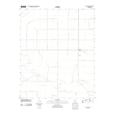
2010 Map of McAlister
USGS Topo · Published 2010About this map
McAlister stands as the primary settlement in this corner of Quay County, defined by a rigid grid of rural roads and seasonal water features. The small community hub is anchored by the McAlister Post Office and the nearby McAlister Cemetery, providing a focal point for local history and genealogical research in this part of eastern New Mexico. The landscape is marked by the winding course of Alamosa Creek, which cuts across the southern portion of the quadrangle. Occasional water bodies like Caballo Lake and Burk Lake interrupt the vast stretches of ranch and farmland. The map reveals a highly structured land management system, where alphabetically and numerically named thoroughfares such as Quay Road AQ and Quay Road 33 partition the terrain into precise rectangular sections, illustrating the modern organization of this high plains agricultural region.
Find a feature on this map
24 named features on this map. Tap any name to fly to it.
Don’t see what you’re looking for? This feature index may not catch every label — zoom into the map to look around manually.
Map Details
Editions of this 2010 McAlister Map
This is the sole edition of this map. No revisions or reprints were ever made.
Other maps of this area

1954 · Clovis
USGS Topo · 1:250,000

1958 · Clovis
USGS Topo · 1:250,000

1970 · Jordan
USGS Topo · 1:24,000
1970 · Cunavea Basin
USGS Topo · 1:24,000

1971 · Ragland
USGS Topo · 1:24,000

1973 · Weber City
USGS Topo · 1:24,000

1973 · House
USGS Topo · 1:24,000
1973 · Peach Canyon
USGS Topo · 1:24,000

1973 · Mc Alister
USGS Topo · 1:24,000

1973 · Field SW
USGS Topo · 1:24,000