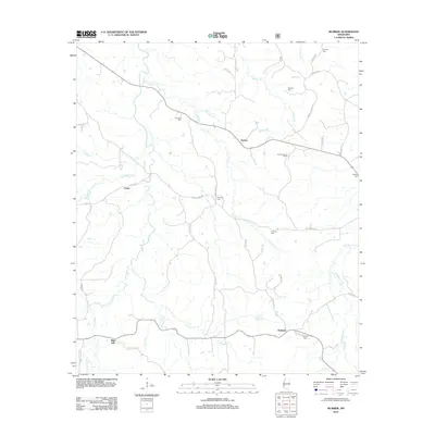
2012 Map of McBride
USGS Topo · Published 2012About this map
McBride and Blue Hill anchor this rural landscape in Jefferson County, where the terrain is defined by a dense network of creek drainages including Johnson Cr and the winding Brandywine Cr. The area maintains a traditional settlement pattern, with small clusters like Peyton and Violet connected by a web of local roads such as Forest Grove Rd and Goza Rd. Genealogists will find significant value in the distribution of family and community burial grounds, including Antioch Cem, Trevillion Cem, and Sarepta Cem, which are scattered throughout the hills. A notable landmark, the Peyton Lookout Tower, stands near the center of the quadrangle, overlooking the various branches like Buckins Cr and Clarks Cr that feed the local watershed.
Find a feature on this map
55 named features on this map. Tap any name to fly to it.
Don’t see what you’re looking for? This feature index may not catch every label — zoom into the map to look around manually.
Map Details
Editions of this 2012 McBride Map
This is the sole edition of this map. No revisions or reprints were ever made.
Other maps of this area

1953 · Natchez
USGS Topo · 1:250,000

1956 · Natchez
USGS Topo · 1:250,000

1959 · Natchez
USGS Topo · 1:250,000

1963 · Port Gibson
USGS Topo · 1:24,000

1963 · Dentville NW
USGS Topo · 1:24,000

1963 · Red Lick
USGS Topo · 1:24,000

1963 · Union Church
USGS Topo · 1:62,500
1963 · Hermanville
USGS Topo · 1:24,000

1963 · McBride
USGS Topo · 1:24,000

1963 · Barlow
USGS Topo · 1:24,000