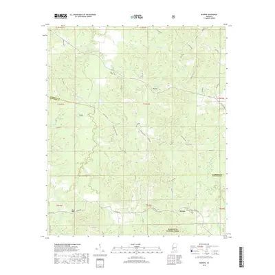
2018 Map of McBride
USGS Topo · Published 2018About this map
Homochitto National Forest anchors the southern boundary of this region, where the terrain is defined by an intricate network of creeks and branches that drain the upland woods. Small settlements like Blue Hill and McBride are situated along the southern roads, while smaller locales such as Violet and Peyton appear further north. The map is particularly detailed regarding family and community cemeteries, documenting numerous sites including Antioch Cem, Sarepta Cem, and Hedrich Cem. The local road network, including McBride Rd and Redlick Rd, follows the ridges between drainages like Clarks Cr and Buckins Cr. This landscape reflects a rural pattern of development where small-scale farming and timber interests likely interacted with the established national forest lands in the early 21st century.
Find a feature on this map
64 named features on this map. Tap any name to fly to it.
Don’t see what you’re looking for? This feature index may not catch every label — zoom into the map to look around manually.
Map Details
Editions of this 2018 McBride Map
This is the sole edition of this map. No revisions or reprints were ever made.
Other maps of this area

1953 · Natchez
USGS Topo · 1:250,000

1956 · Natchez
USGS Topo · 1:250,000

1959 · Natchez
USGS Topo · 1:250,000

1963 · Port Gibson
USGS Topo · 1:24,000

1963 · Dentville NW
USGS Topo · 1:24,000

1963 · Red Lick
USGS Topo · 1:24,000

1963 · Union Church
USGS Topo · 1:62,500
1963 · Hermanville
USGS Topo · 1:24,000

1963 · McBride
USGS Topo · 1:24,000

1963 · Barlow
USGS Topo · 1:24,000