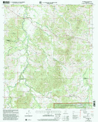
2000 Map of McBride
USGS Topo · Published 2002About this map
Homochitto National Forest encompasses the southern half of this landscape, where the border between Claiborne Co and Jefferson Co follows the winding path of Clarks Creek. This area is defined by a dense network of country churches and small family cemeteries, suggesting a deeply rooted rural community structure. Notable spiritual landmarks include St Peter Ch, Philadelphia Ch, and Sarepta Ch, while local lineage can be traced through sites like Hedrich Cem and Sanders Cem. Small settlements like McBride and Peyton serve as local hubs in a terrain of deep creek valleys, including Buckins Creek and Brandywine Creek. The presence of Gravel Pits and the Peyton Lookout indicates a mix of local resource extraction and forest management within the undulating topography of Griffing Ridge.
Find a feature on this map
38 named features on this map. Tap any name to fly to it.
Don’t see what you’re looking for? This feature index may not catch every label — zoom into the map to look around manually.
Map Details
Editions of this 2000 McBride Map
This is the sole edition of this map. No revisions or reprints were ever made.
Other maps of this area

1953 · Natchez
USGS Topo · 1:250,000

1956 · Natchez
USGS Topo · 1:250,000

1959 · Natchez
USGS Topo · 1:250,000

1963 · Port Gibson
USGS Topo · 1:24,000

1963 · Dentville NW
USGS Topo · 1:24,000

1963 · Red Lick
USGS Topo · 1:24,000

1963 · Union Church
USGS Topo · 1:62,500
1963 · Hermanville
USGS Topo · 1:24,000

1963 · McBride
USGS Topo · 1:24,000

1963 · Barlow
USGS Topo · 1:24,000