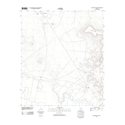
2010 Map of McCamey South
USGS Topo · Published 2010About this map
The Pecos River snakes across the southern portion of this landscape, its winding course defining the geography south of Mc Camey. This area of West Texas is characterized by the prominent elevation of the Southwest Mesa to the east and the Bobcat Hills to the west, creating a corridor for energy infrastructure and ranching. The map highlights the industrial character of the region during the early 21st century, particularly at the Tippett Oil Field and the nearby Tippett Gas Plant. Local connectivity is anchored by roads such as Hwy 1901 and Ranch Rd 305, which serve the rural homesteads like the Patton Ranch and the Upton County Airport. The presence of Tunas Creek feeding toward the river valley emphasizes the importance of drainage patterns in this arid terrain.
Find a feature on this map
15 named features on this map. Tap any name to fly to it.
Don’t see what you’re looking for? This feature index may not catch every label — zoom into the map to look around manually.
Map Details
Editions of this 2010 McCamey South Map
This is the sole edition of this map. No revisions or reprints were ever made.
Other maps of this area

1928 · Crane
USGS Topo · 1:125,000

1929 · Independence Draw Quadrangle
USGS Topo · 1:125,000

1954 · Pecos
USGS Topo · 1:250,000

1954 · Fort Stockton
USGS Topo · 1:250,000

1957 · Pecos
USGS Topo · 1:250,000

1958 · Fort Stockton
USGS Topo · 1:250,000

1969 · Indian Mesa
USGS Topo · 1:24,000

1969 · Bakersfield
USGS Topo · 1:24,000
1969 · Indian Mesa NE
USGS Topo · 1:24,000

1972 · Girvin NE
USGS Topo · 1:24,000