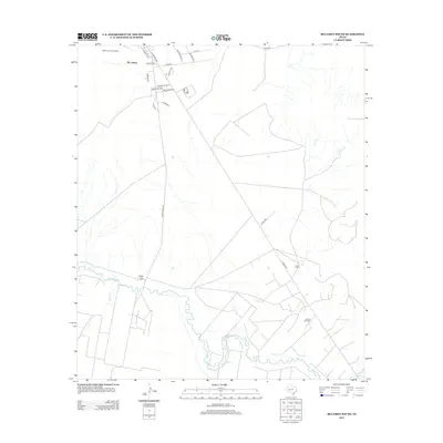
2013 Map of McCamey South
USGS Topo · Published 2013About this map
The southern outskirts of Mc Camey and the industrial landscape of the Permian Basin are documented here along the meandering Pecos River. This 2013 survey illustrates the convergence of urban infrastructure and energy production, with the Tippett Gas Plant and extensive Tippett Oil Field marking the desert terrain south of the city. The town's grid extends southward via roads like Medical Dr and Country Club Ln, while the Upton County Airport serves as a key transit point for the region. Further south, the landscape transitions into ranchland, including the Patton Ranch, intersected by Ranch Road 1901 and the waterway of Tunas Cr. The map provides a clear look at the network of county and ranch roads that support the local petroleum economy and rural landholdings.
Find a feature on this map
25 named features on this map. Tap any name to fly to it.
Don’t see what you’re looking for? This feature index may not catch every label — zoom into the map to look around manually.
Map Details
Editions of this 2013 McCamey South Map
This is the sole edition of this map. No revisions or reprints were ever made.
Other maps of this area

1928 · Crane
USGS Topo · 1:125,000

1929 · Independence Draw Quadrangle
USGS Topo · 1:125,000

1954 · Pecos
USGS Topo · 1:250,000

1954 · Fort Stockton
USGS Topo · 1:250,000

1957 · Pecos
USGS Topo · 1:250,000

1958 · Fort Stockton
USGS Topo · 1:250,000

1969 · Indian Mesa
USGS Topo · 1:24,000

1969 · Bakersfield
USGS Topo · 1:24,000
1969 · Indian Mesa NE
USGS Topo · 1:24,000

1972 · Girvin NE
USGS Topo · 1:24,000