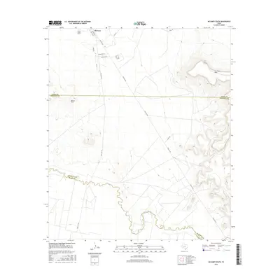
2016 Map of McCamey South
USGS Topo · Published 2016About this map
The southern outskirts of McCamey give way to the expansive Edwards Plateau landscape of West Texas, where the terrain is defined by the meandering course of the Pecos River. This 2016 survey captures the transition from the town's street grid, including Houston Ave and Emerson Ave, into the surrounding ranchland and industrial transport corridors. The southern reaches are marked by significant topographical features such as the Southwest Mesa and the Bobcat Hills, which rise above the river valley. Infrastructure critical to the Permian Basin region is evident, from the Upton County Airport at the northern edge to the network of state roads like Ranch Rd 1901 and Ranch Rd 305 that facilitate movement across the Upton, Crockett, and Pecos county lines.
Find a feature on this map
18 named features on this map. Tap any name to fly to it.
Don’t see what you’re looking for? This feature index may not catch every label — zoom into the map to look around manually.
Map Details
Editions of this 2016 McCamey South Map
This is the sole edition of this map. No revisions or reprints were ever made.
Other maps of this area

1928 · Crane
USGS Topo · 1:125,000

1929 · Independence Draw Quadrangle
USGS Topo · 1:125,000

1954 · Pecos
USGS Topo · 1:250,000

1954 · Fort Stockton
USGS Topo · 1:250,000

1957 · Pecos
USGS Topo · 1:250,000

1958 · Fort Stockton
USGS Topo · 1:250,000

1969 · Indian Mesa
USGS Topo · 1:24,000

1969 · Bakersfield
USGS Topo · 1:24,000
1969 · Indian Mesa NE
USGS Topo · 1:24,000

1972 · Girvin NE
USGS Topo · 1:24,000