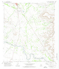
1972 Map of McCamey South
USGS Topo · Published 1974About this map
Mc Camey anchors the northern edge of this West Texas survey, serving as a hub for the surrounding oil and ranching landscape. The town's local infrastructure is well-defined, featuring a Hospital, Country Club, Athletic Field, and a Rodeo Ground adjacent to the local Cem. This 1972 snapshot reveals a region where traditional agriculture and modern industrial extraction coexist. South of the town, the landscape transitions into the extensive El Cinco Oil Field and Tippett Oil Field, populated with numerous Oil Wells and a Tippett Gas Plant. The Pecos River meanders across the southern portion of the quadrangle, accompanied by the historic Old Spanish Ditch. Evidence of the area's agricultural roots remains visible through features like the Cotton Gin and the Patton Ranch, even as an extensive network of pipelines and an Aqueduct cut across the arid terrain toward the Southwest Mesa.
Find a feature on this map
27 named features on this map. Tap any name to fly to it.
Don’t see what you’re looking for? This feature index may not catch every label — zoom into the map to look around manually.
Map Details
Editions of this 1972 McCamey South Map
This is the sole edition of this map. No revisions or reprints were ever made.
Other maps of this area

1928 · Crane
USGS Topo · 1:125,000

1929 · Independence Draw Quadrangle
USGS Topo · 1:125,000

1954 · Pecos
USGS Topo · 1:250,000

1954 · Fort Stockton
USGS Topo · 1:250,000

1957 · Pecos
USGS Topo · 1:250,000

1958 · Fort Stockton
USGS Topo · 1:250,000

1969 · Indian Mesa
USGS Topo · 1:24,000

1969 · Bakersfield
USGS Topo · 1:24,000
1969 · Indian Mesa NE
USGS Topo · 1:24,000

1972 · Girvin NE
USGS Topo · 1:24,000