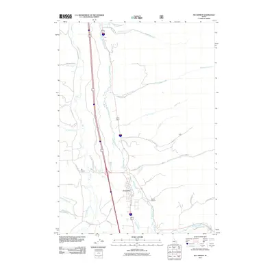
2011 Map of McCammon
USGS Topo · Published 2011About this map
McCammon serves as the primary hub of this landscape where the Portneuf River and Marsh Creek converge, shaping a corridor vital for regional transport and irrigation. The presence of the Portneuf Marsh Valley Canal reflects the agricultural development of this Idaho valley, diverting water to sustain the surrounding terrain. To the north, the small settlement of Onyx sits near the winding river, while several canyons and creeks drain from the higher elevations into the central basin. Numerous locally named drainages, such as Robbers Roost Creek, Quinn Creek, and Harkness Creek, cut through the hills, providing a detailed look at the rural road network and water management systems in place at the start of the 21st century. This survey documents the intersection of natural waterways and human infrastructure, showing how family-named roads like Gary Thompson connect outlying areas to the town center.
Find a feature on this map
35 named features on this map. Tap any name to fly to it.
Don’t see what you’re looking for? This feature index may not catch every label — zoom into the map to look around manually.
Map Details
Editions of this 2011 McCammon Map
This is the sole edition of this map. No revisions or reprints were ever made.
Other maps of this area

1937 · Pocatello
USGS Topo · 1:48,000

1944 · Pocatello
USGS Topo · 1:62,500

1954 · Pocatello
USGS Topo · 1:250,000

1958 · Pocatello
USGS Topo · 1:250,000

1968 · Bear Camp Gulch
USGS Topo · 1:24,000

1968 · Hawkins
USGS Topo · 1:24,000

1968 · Lava Hot Springs
USGS Topo · 1:24,000
1968 · Arimo
USGS Topo · 1:24,000
1968 · Bonneville Peak
USGS Topo · 1:24,000
1968 · Haystack Mtn
USGS Topo · 1:24,000