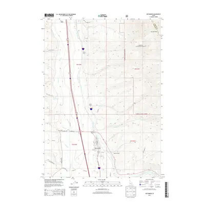
2013 Map of McCammon
USGS Topo · Published 2013About this map
McCammon serves as the central hub of this Idaho landscape, where the Portneuf River and Marsh Cr converge within the wide expanse of Marsh Valley. The settlement pattern follows the valley floor, with the small community of Onyx situated to the north along the river's winding course. This 2013 survey illustrates a complex water management system, notably the Portneuf Marsh Valley Canal, which skirts the eastern edge of the valley near the base of the rising Portneuf Range. To the east, the terrain climbs sharply into the Caribou National Forest, a region defined by deeply cut drainages such as Robbers Roost Cr, Twomile Cr, and Harkness Cr. The map details the transition from the irrigated agricultural lands of the valley to the protected forest highlands, providing a clear view of the road network including S Old Highway 91 and various canyon access points like Mullen Canyon.
Find a feature on this map
45 named features on this map. Tap any name to fly to it.
Don’t see what you’re looking for? This feature index may not catch every label — zoom into the map to look around manually.
Map Details
Editions of this 2013 McCammon Map
This is the sole edition of this map. No revisions or reprints were ever made.
Other maps of this area

1937 · Pocatello
USGS Topo · 1:48,000

1944 · Pocatello
USGS Topo · 1:62,500

1954 · Pocatello
USGS Topo · 1:250,000

1958 · Pocatello
USGS Topo · 1:250,000

1968 · Bear Camp Gulch
USGS Topo · 1:24,000

1968 · Hawkins
USGS Topo · 1:24,000

1968 · Lava Hot Springs
USGS Topo · 1:24,000
1968 · Arimo
USGS Topo · 1:24,000
1968 · Bonneville Peak
USGS Topo · 1:24,000
1968 · Haystack Mtn
USGS Topo · 1:24,000