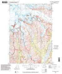
1993 Map of McCarthy C-5
USGS Topo · Published 2002About this map
The Jumbo Mine and Mother Lode Mine sit high on the slopes above McCarthy Creek, marking the legacy of high-altitude copper mining in this corner of the Alaska territory. Published in 2002 using data compiled across several decades, this map details the complex glacial landscape where the Regal Glacier and West Fork Glacier dominate the northern terrain. The confluence of the Nizina River and Chitistone River in the southeast provides a natural corridor through the mountains, while landmarks like Regal Mtn and Bonanza Peak define the dramatic vertical relief. Much of the area is contained within the Wrangell-Saint Elias National Park and Preserve, with the Wrangell-Saint Elias Wilderness boundary cutting through the heart of the glacial basins and ridges like Bonanza Ridge.
Find a feature on this map
27 named features on this map. Tap any name to fly to it.
Don’t see what you’re looking for? This feature index may not catch every label — zoom into the map to look around manually.
Map Details
Editions of this 1993 McCarthy C-5 Map
This is the sole edition of this map. No revisions or reprints were ever made.
Other maps of this area

1951 · McCarthy
USGS Topo · 1:250,000

1959 · McCarthy B-6
USGS Topo · 1:63,360

1959 · McCarthy C-5
USGS Topo · 1:63,360

1959 · McCarthy B-5
USGS Topo · 1:63,360

1959 · McCarthy C-4
USGS Topo · 1:63,360

1959 · McCarthy B-4
USGS Topo · 1:63,360

1959 · McCarthy C-6
USGS Topo · 1:63,360

1960 · McCarthy D-6
USGS Topo · 1:63,360
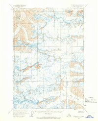
1960 · McCarthy D-5
USGS Topo · 1:63,360

1960 · McCarthy D-4
USGS Topo · 1:63,360