
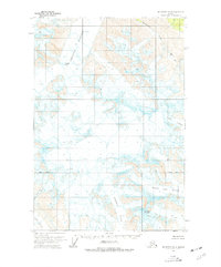
1960 Map of McCarthy D-4
USGS Topo · Published 1966About this map
Chisana Glacier dominates the northern expanse of this high-altitude landscape, its ice fields marked by numerous crevasses as it flows through the terrain. This 1960 field-annotated survey captures a frozen wilderness defined by massive ice movements and high peaks, such as Frederika Mountain, which stands between the Frederika Glacier and the Middle Fork Glacier. The intricate contour lines reveal the dramatic verticality of features like the Jumpoff Icefall and the steep passage at Bow Pass. This map is particularly notable for its documentation of the glacial hydrology in the Wrangell Mountains region, showing the headwaters of Boomerang Creek and Bow Creek emerging from the receding ice. Remote and unroaded, the area is charted with a focus on natural barriers and navigational landmarks used by early aviators and mountain explorers.
Find a feature on this map
13 named features on this map. Tap any name to fly to it.
Don’t see what you’re looking for? This feature index may not catch every label — zoom into the map to look around manually.
Map Details
Editions of this 1960 McCarthy D-4 Map
2 editions found
Other maps of this area

1950 · Nabesna
USGS Topo · 1:250,000

1951 · McCarthy
USGS Topo · 1:250,000

1951 · Nabesna
USGS Topo · 1:250,000

1959 · McCarthy C-5
USGS Topo · 1:63,360

1959 · McCarthy C-4
USGS Topo · 1:63,360

1959 · McCarthy D-3
USGS Topo · 1:63,360

1959 · McCarthy C-3
USGS Topo · 1:63,360

1959 · Nabesna A-4
USGS Topo · 1:63,360

1960 · Nabesna A-3
USGS Topo · 1:63,360

1960 · Nabesna
USGS Topo · 1:250,000