
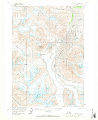
1959 Map of McCarthy C-3
USGS Topo · Published 1964About this map
Russell Glacier dominates the eastern half of this high-altitude Alaskan landscape, where the ice flows south from the drainage of the White River. This 1959 survey provides a precise look at the glaciated terrain of the Wrangell-St. Elias region during the mid-20th century. A remote Landing Strip and an isolated Cabin near Upper Skolai Lake indicate the sparse human footprint in this wilderness, which was primarily traversed by routes like The Goat Trail. This trail skirts the steep canyons of the Chitistone River, connecting the Chitistone Pass to the surrounding peaks. Significant geological markers such as Castle Mountain and Skolai Pass serve as landmarks for navigation between the massive ice fields of the Chitistone Glacier and the headwaters of Flood Creek and Wiley Cr.
Find a feature on this map
17 named features on this map. Tap any name to fly to it.
Don’t see what you’re looking for? This feature index may not catch every label — zoom into the map to look around manually.
Map Details
Editions of this 1959 McCarthy C-3 Map
2 editions found
Other maps of this area

1951 · McCarthy
USGS Topo · 1:250,000

1959 · McCarthy C-4
USGS Topo · 1:63,360

1959 · McCarthy B-4
USGS Topo · 1:63,360

1959 · McCarthy D-3
USGS Topo · 1:63,360

1959 · McCarthy D-2
USGS Topo · 1:63,360

1959 · McCarthy B-2
USGS Topo · 1:63,360

1959 · McCarthy C-2
USGS Topo · 1:63,360

1959 · McCarthy B-3
USGS Topo · 1:63,360

1960 · McCarthy D-4
USGS Topo · 1:63,360

1960 · McCarthy
USGS Topo · 1:250,000