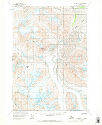
1959 Map of McCarthy C-3
USGS Topo · Published 1970About this map
The Goat Trail winds through high mountain passes in this 1950s study of the Wrangell Mountains, tracing a vital route between the Chitistone River and Skolai Pass. This survey illustrates the glacial landscape of the late fifties, dominated by the massive Russell Glacier and Chitistone Glacier, which are marked with numerous crevasses that define the navigation of the era.
Find a feature on this map
19 named features on this map. Tap any name to fly to it.
Don’t see what you’re looking for? This feature index may not catch every label — zoom into the map to look around manually.
Map Details
Editions of this 1959 McCarthy C-3 Map
2 editions found
Other maps of this area

1951 · McCarthy
USGS Topo · 1:250,000

1959 · McCarthy C-4
USGS Topo · 1:63,360

1959 · McCarthy B-4
USGS Topo · 1:63,360

1959 · McCarthy D-3
USGS Topo · 1:63,360

1959 · McCarthy D-2
USGS Topo · 1:63,360

1959 · McCarthy C-3
USGS Topo · 1:63,360

1959 · McCarthy B-2
USGS Topo · 1:63,360

1959 · McCarthy C-2
USGS Topo · 1:63,360

1959 · McCarthy B-3
USGS Topo · 1:63,360

1960 · McCarthy D-4
USGS Topo · 1:63,360