
1959 Map of McCarthy B-2
USGS Topo · Published 1966About this map
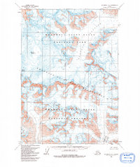
Mount Bona and Mount Churchill dominate this high-altitude Alaskan landscape as it was documented in the late 1950s. The terrain is defined by massive glacial systems, specifically the broad expanse of Klutlan Glacier and the southern reach of Barnard Glacier. Mapped using photogrammetric methods from 1957 aerial photography, the sheet provides a stark record of a roadless wilderness where ice and elevation are the primary features. Numerous crevasses are marked across the glacial surfaces, indicating the dynamic and hazardous nature of the ice fields during this period. The absence of any human-made infrastructure, trails, or settlements underscores the isolation of this sector of the Saint Elias Mountains during the mid-twentieth century.
Find a feature on this map
5 named features on this map. Tap any name to fly to it.
Don’t see what you’re looking for? This feature index may not catch every label — zoom into the map to look around manually.
Map Details
Editions of this 1959 McCarthy B-2 Map
2 editions found
Other maps of this area

1951 · McCarthy
USGS Topo · 1:250,000

1959 · McCarthy C-3
USGS Topo · 1:63,360

1959 · McCarthy A-2
USGS Topo · 1:63,360

1959 · McCarthy C-1
USGS Topo · 1:63,360

1959 · McCarthy B-1
USGS Topo · 1:63,360

1959 · McCarthy A-3
USGS Topo · 1:63,360
1959 · McCarthy A-1
USGS Topo · 1:63,360

1959 · McCarthy C-2
USGS Topo · 1:63,360

1959 · McCarthy B-3
USGS Topo · 1:63,360

1960 · McCarthy
USGS Topo · 1:250,000