
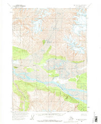
1959 Map of McCarthy A-3
USGS Topo · Published 1966About this map
The Chitina River flows through a landscape dominated by massive ice flows and glacial tributaries in this late 1950s survey. The map depicts the terminus of the Short River and the expansive reach of the Barnard Glacier as it feeds into the central valley. Significant ice masses like Hawkins Glacier carve through the northern elevations, while the southern terrain is marked by a series of mineral-named drainages, including Graphite Creek, Quartz Creek, and Iron Creek. Rising above the glacial plains, Gibraltar Hill serves as a prominent landmark near Clear Stream. This survey, based on 1957 aerial photography, captures the intricate drainage patterns and topographical character of the Alaskan interior before modern shifts in glacial geography, offering a precise look at the region's wilderness state.
Find a feature on this map
16 named features on this map. Tap any name to fly to it.
Don’t see what you’re looking for? This feature index may not catch every label — zoom into the map to look around manually.
Map Details
Editions of this 1959 McCarthy A-3 Map
2 editions found
Other maps of this area

1950 · Bering Glacier
USGS Topo · 1:250,000

1951 · McCarthy
USGS Topo · 1:250,000

1951 · Bering Glacier
USGS Topo · 1:250,000

1959 · McCarthy A-4
USGS Topo · 1:63,360

1959 · McCarthy B-4
USGS Topo · 1:63,360

1959 · McCarthy A-2
USGS Topo · 1:63,360

1959 · McCarthy B-2
USGS Topo · 1:63,360

1959 · Bering Glacier
USGS Topo · 1:250,000

1959 · McCarthy B-3
USGS Topo · 1:63,360

1960 · McCarthy
USGS Topo · 1:250,000