
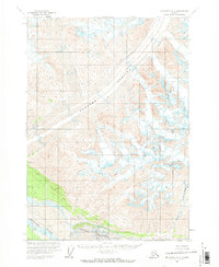
1959 Map of McCarthy A-2
USGS Topo · Published 1966About this map
Barnard Glacier dominates this landscape, its massive ice flow carving through the terrain toward the southern reaches of the quadrangle. In the lower portion of the map, the Chitina River valley serves as a primary corridor, where the glacial influence remains visible through the sprawling Chitina Glacier. This 1950s survey documents a wilderness largely defined by its natural topography rather than human infrastructure, as evidenced by the lack of road classifications. The Huberts Landing Area on the north bank of the river provides one of the few named points of human activity in this remote region. Glacial features are recorded in detail, including specific zones of Crevasses that mark the shifting, dangerous surface of the ice fields. This map captures the raw state of the Alaskan interior during a period of extensive photogrammetric mapping by the International Boundary Commission and other federal agencies.
Find a feature on this map
5 named features on this map. Tap any name to fly to it.
Don’t see what you’re looking for? This feature index may not catch every label — zoom into the map to look around manually.
Map Details
Editions of this 1959 McCarthy A-2 Map
2 editions found
Other maps of this area

1950 · Bering Glacier
USGS Topo · 1:250,000

1951 · McCarthy
USGS Topo · 1:250,000

1951 · Bering Glacier
USGS Topo · 1:250,000

1959 · McCarthy B-2
USGS Topo · 1:63,360

1959 · McCarthy B-1
USGS Topo · 1:63,360

1959 · McCarthy A-3
USGS Topo · 1:63,360
1959 · McCarthy A-1
USGS Topo · 1:63,360

1959 · Bering Glacier
USGS Topo · 1:250,000

1959 · McCarthy B-3
USGS Topo · 1:63,360

1960 · McCarthy
USGS Topo · 1:250,000