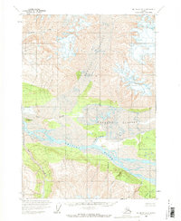
1959 Map of McCarthy A-3
USGS Topo · Published 1969About this map
Massive glacial systems and braided river valleys dominate this mid-century survey of the Wrangell Mountains region. The Chitina River flows through the central valley, receiving the glacial melt of the Short River and numerous mountain drainages. The landscape is defined by the immense Hawkins Glacier and Barnard Glacier, which carve through the high elevations, leaving behind a complex network of creeks like Goat Creek and Erickson Creek. Standing as a prominent navigation point above the convergence of waterways is Gibraltar Hill. This map, based on 1957 aerial photography, captures the raw hydrological state of the Alaskan wilderness before significant human infrastructure was established in the quadrangle, illustrating how the ice and water dictate the area's natural boundaries.
Find a feature on this map
12 named features on this map. Tap any name to fly to it.
Don’t see what you’re looking for? This feature index may not catch every label — zoom into the map to look around manually.
Map Details
Editions of this 1959 McCarthy A-3 Map
2 editions found
Other maps of this area

1950 · Bering Glacier
USGS Topo · 1:250,000

1951 · McCarthy
USGS Topo · 1:250,000

1951 · Bering Glacier
USGS Topo · 1:250,000

1959 · McCarthy A-4
USGS Topo · 1:63,360

1959 · McCarthy B-4
USGS Topo · 1:63,360

1959 · McCarthy A-2
USGS Topo · 1:63,360

1959 · McCarthy B-2
USGS Topo · 1:63,360

1959 · McCarthy A-3
USGS Topo · 1:63,360

1959 · Bering Glacier
USGS Topo · 1:250,000

1959 · McCarthy B-3
USGS Topo · 1:63,360