
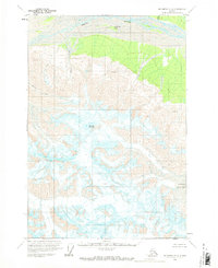
1959 Map of McCarthy C-2
USGS Topo · Published 1966About this map
White River flows across the northern edge of this high-altitude landscape, where the braided channels of the river surround North Fork Island. The terrain is dominated by the massive presence of Mount Sulzer and the sprawling Giffin Glacier to the south. This 1957 photogrammetric survey captures the stark glacial geography of the region before significant modern changes, documenting a maze of Crevasses and ice fields that defined the local environment. Evidence of human presence is sparse but specific, marked by the location of Cabins along the northern riverbank and the Black Eagle landmark. The drainage system is clearly articulated through the courses of Sheep Creek, Wiley Creek, and Divide Creek, illustrating how seasonal meltwaters from the high peaks and glaciers feed into the larger river basin.
Find a feature on this map
11 named features on this map. Tap any name to fly to it.
Don’t see what you’re looking for? This feature index may not catch every label — zoom into the map to look around manually.
Map Details
Editions of this 1959 McCarthy C-2 Map
2 editions found
Other maps of this area

1951 · McCarthy
USGS Topo · 1:250,000

1959 · McCarthy D-1
USGS Topo · 1:63,360

1959 · McCarthy D-3
USGS Topo · 1:63,360

1959 · McCarthy D-2
USGS Topo · 1:63,360

1959 · McCarthy C-3
USGS Topo · 1:63,360

1959 · McCarthy C-1
USGS Topo · 1:63,360

1959 · McCarthy B-2
USGS Topo · 1:63,360

1959 · McCarthy B-1
USGS Topo · 1:63,360

1959 · McCarthy B-3
USGS Topo · 1:63,360

1960 · McCarthy
USGS Topo · 1:250,000