
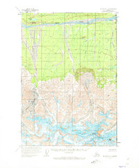
1959 Map of McCarthy C-1
USGS Topo · Published 1966About this map
The White River corridor dominates the northern reaches of this Alaskan interior landscape, where glacial runoff feeds a network of drainage systems such as Holmes Creek and Kletsan Creek. To the south, the terrain ascends into the dramatic heights of the Saint Elias Mountains along the United States Canada international boundary. Massive ice fields define the topography here, most notably the Natazhat Glacier and the Giffin Glacier, which flow from high peaks including Mount Natazhat and Mount Riggs.
Find a feature on this map
14 named features on this map. Tap any name to fly to it.
Don’t see what you’re looking for? This feature index may not catch every label — zoom into the map to look around manually.
Map Details
Editions of this 1959 McCarthy C-1 Map
2 editions found
Other maps of this area

1951 · McCarthy
USGS Topo · 1:250,000

1959 · McCarthy D-1
USGS Topo · 1:63,360

1959 · McCarthy D-2
USGS Topo · 1:63,360

1959 · McCarthy B-2
USGS Topo · 1:63,360

1959 · McCarthy B-1
USGS Topo · 1:63,360

1959 · McCarthy C-2
USGS Topo · 1:63,360

1960 · McCarthy
USGS Topo · 1:250,000
2017 · McCarthy C-1 SE
USGS Topo · 1:25,000
2017 · McCarthy B-1 NE
USGS Topo · 1:25,000
2017 · McCarthy C-2 NE
USGS Topo · 1:25,000