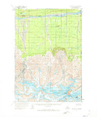
1959 Map of McCarthy C-1
USGS Topo · Published 1973About this map
The Alaska Yukon international boundary defines the eastern edge of this 1950s survey, where the massive ice fields of Guerin Glacier and Giffin Glacier dominate the high-altitude landscape. Rising above the glacial flow is the prominent peak of Mount Natazhat, a central landmark in this roadless wilderness. To the north, the White River carves a broad valley, fed by numerous tributaries including Holmes Creek and Cub Creek. This area remains largely untouched by development, shown here just as it was when mapped from 1957 aerial photography. The terrain is characterized by dramatic elevation changes from the Pingpong Lakes near Pingpong Mountain up to the frozen expanse of the Natazhat Glacier and the neighboring Mount Riggs.
Find a feature on this map
15 named features on this map. Tap any name to fly to it.
Don’t see what you’re looking for? This feature index may not catch every label — zoom into the map to look around manually.
Map Details
Editions of this 1959 McCarthy C-1 Map
2 editions found
Other maps of this area

1951 · McCarthy
USGS Topo · 1:250,000

1959 · McCarthy D-1
USGS Topo · 1:63,360

1959 · McCarthy D-2
USGS Topo · 1:63,360

1959 · McCarthy C-1
USGS Topo · 1:63,360

1959 · McCarthy B-2
USGS Topo · 1:63,360

1959 · McCarthy B-1
USGS Topo · 1:63,360

1959 · McCarthy C-2
USGS Topo · 1:63,360

1960 · McCarthy
USGS Topo · 1:250,000
2017 · McCarthy C-1 SE
USGS Topo · 1:25,000
2017 · McCarthy B-1 NE
USGS Topo · 1:25,000