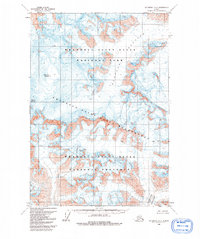
1959 Map of McCarthy B-2
USGS Topo · Published 1992About this map
Mount Bona and Mount Churchill dominate this high-altitude Alaskan landscape, where ice and rock define the topography. The 1959 field survey documents a world of permanent snowfields and massive glacial systems, most notably the sprawling Klutlan Glacier and the Barnard Glacier at the southern edge. The map highlights the intersection of federally protected lands, including the Wrangell-Saint Elias National Park, the Wrangell-Saint Elias Wilderness, and the Wrangell-Saint Elias National Preserve. Topographic contours reveal the extreme elevation changes between peaks and valleys, while numerous crevasses are explicitly marked across the glacial surfaces, indicating the dynamic and hazardous nature of the ice at the time of the photogrammetric mapping in 1957.
Find a feature on this map
8 named features on this map. Tap any name to fly to it.
Don’t see what you’re looking for? This feature index may not catch every label — zoom into the map to look around manually.
Map Details
Editions of this 1959 McCarthy B-2 Map
2 editions found
Other maps of this area

1951 · McCarthy
USGS Topo · 1:250,000

1959 · McCarthy C-3
USGS Topo · 1:63,360

1959 · McCarthy A-2
USGS Topo · 1:63,360

1959 · McCarthy C-1
USGS Topo · 1:63,360

1959 · McCarthy B-2
USGS Topo · 1:63,360

1959 · McCarthy B-1
USGS Topo · 1:63,360

1959 · McCarthy A-3
USGS Topo · 1:63,360
1959 · McCarthy A-1
USGS Topo · 1:63,360

1959 · McCarthy C-2
USGS Topo · 1:63,360

1959 · McCarthy B-3
USGS Topo · 1:63,360