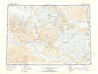
1951 Map of McCarthy
USGS Topo · Published 1951About this map
The Wrangell Mountains dominate this 1951 reconnaissance survey, showing a landscape defined by massive ice fields and the high peaks of the Alaska interior. The settlement of McCarthy stands as a primary hub for the region, positioned near the confluence of the Nizina River and the Kennicott glacier system. This map documents a transitional era in Alaskan transport, where traditional overland routes are supplemented by remote infrastructure like the Airstrip near McCarthy and the Bremner Airstrip to the south.
Find a feature on this map
144 named features on this map. Tap any name to fly to it.
Don’t see what you’re looking for? This feature index may not catch every label — zoom into the map to look around manually.
Map Details
Editions of this 1951 McCarthy Map
4 editions found
Other maps of this area

1948 · Cordova
USGS Topo · 1:250,000

1950 · Nabesna
USGS Topo · 1:250,000

1950 · McCarthy A-8
USGS Topo · 1:63,360

1950 · Bering Glacier
USGS Topo · 1:250,000

1951 · McCarthy
USGS Topo · 1:250,000

1951 · Gulkana
USGS Topo · 1:250,000

1951 · Bering Glacier
USGS Topo · 1:250,000

1951 · Nabesna
USGS Topo · 1:250,000

1951 · Cordova
USGS Topo · 1:250,000

1951 · Mt Saint Elias
USGS Topo · 1:250,000