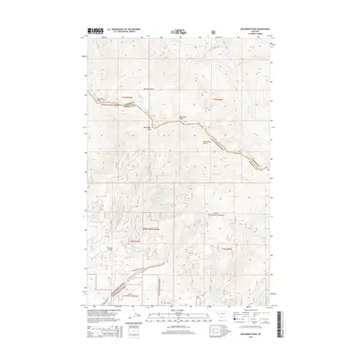
2014 Map of McCormick Peak
USGS Topo · Published 2014About this map
McCormick Peak and Blackrock Peak anchor the high country along the Reservation Divide, a prominent ridge that defines the boundary between the Sanders and Missoula county line in western Montana. This area within the Lolo National Forest is characterized by a network of drainage basins, including the Blacktail Basin and Favorite Gulch. The map illustrates the complex hydrography of the region, where the headwaters of W Fork Revais Cr, Middle Fork Revais Cr, and E Fork Revais Cr descend from the peaks. Historical transport into these high-altitude landscapes is represented by routes such as Upper Kennedy Creek Rd and Butler Creek Rd, which provide access to the drainages of Kennedy Cr and Butler Cr at the southern end of the survey.
Find a feature on this map
24 named features on this map. Tap any name to fly to it.
Don’t see what you’re looking for? This feature index may not catch every label — zoom into the map to look around manually.
Map Details
Editions of this 2014 McCormick Peak Map
This is the sole edition of this map. No revisions or reprints were ever made.
Other maps of this area

1956 · Wallace
USGS Topo · 1:250,000

1959 · Tarkio
USGS Topo · 1:62,500

1959 · Alberton
USGS Topo · 1:62,500

1959 · Perma
USGS Topo · 1:62,500

1960 · Wallace
USGS Topo · 1:250,000

1964 · Dixon
USGS Topo · 1:24,000

1964 · Mc Donald
USGS Topo · 1:24,000
1983 · Stark South
USGS Topo · 1:24,000

1984 · Stark North
USGS Topo · 1:24,000
1984 · Huson
USGS Topo · 1:24,000