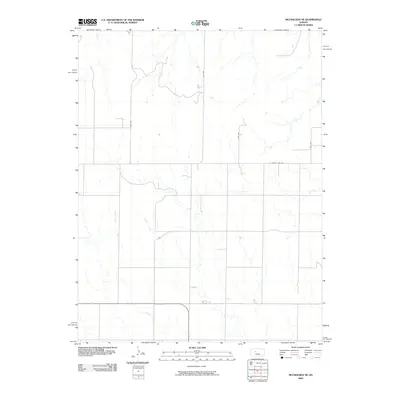
2009 Map of McCracken NE
USGS Topo · Published 2009About this map
Snake Creek meanders through the heart of this Ellis County landscape, defining the natural drainage patterns of the rural high plains in the early 21st century. The map reveals a strictly regulated agrarian grid, where the passage of time is marked by a systematic road network rather than dense town centers. Key thoroughfares such as Ellis Ave and S County Line Rd provide the primary infrastructure for this farming community, reflecting the enduring township-and-range land divisions that have shaped the region since its early settlement. This survey illustrates the subtle topographical shifts of the Kansas prairie, captured just before the widespread expansion of modern digital mapping standards, providing a clear record of property access lines and waterway paths in a quiet corner of the state.
Find a feature on this map
6 named features on this map. Tap any name to fly to it.
Don’t see what you’re looking for? This feature index may not catch every label — zoom into the map to look around manually.
Map Details
Editions of this 2009 McCracken NE Map
This is the sole edition of this map. No revisions or reprints were ever made.
Other maps of this area

1893 · Ellis
USGS Topo · 1:125,000

1896 · Hays
USGS Topo · 1:125,000

1955 · Great Bend
USGS Topo · 1:250,000

1957 · Great Bend
USGS Topo · 1:250,000

1958 · Great Bend
USGS Topo · 1:250,000

1961 · Antonino
USGS Topo · 1:24,000

1965 · Mc Cracken
USGS Topo · 1:24,000

1966 · Mc Cracken SW
USGS Topo · 1:24,000

1966 · Hargrave
USGS Topo · 1:24,000
1968 · La Crosse NW
USGS Topo · 1:24,000