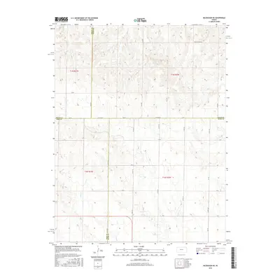
2015 Map of McCracken NE
USGS Topo · Published 2015About this map
The convergence of four Kansas counties—Trego, Ellis, Ness, and Rush—defines this landscape of the High Plains. The terrain is deeply incised by the drainage of Snake Creek, which winds through the southwestern sections and shapes the local topography. This 2015 survey reveals a rigid section-line road network that overlays the undulating ground, where routes like Ellis Ave and S Co Line Rd follow the cardinal directions regardless of the draws and ridges they cross. Notable for its evocative name in the northern reaches, Chetolah Gold Rd suggests a connection to early regional mining lore or local history, while the remainder of the map documents a sparse, agricultural environment dominated by large-scale land divisions and public land survey markers.
Find a feature on this map
30 named features on this map. Tap any name to fly to it.
Don’t see what you’re looking for? This feature index may not catch every label — zoom into the map to look around manually.
Map Details
Editions of this 2015 McCracken NE Map
This is the sole edition of this map. No revisions or reprints were ever made.
Other maps of this area

1893 · Ellis
USGS Topo · 1:125,000

1896 · Hays
USGS Topo · 1:125,000

1955 · Great Bend
USGS Topo · 1:250,000

1957 · Great Bend
USGS Topo · 1:250,000

1958 · Great Bend
USGS Topo · 1:250,000

1961 · Antonino
USGS Topo · 1:24,000

1965 · Mc Cracken
USGS Topo · 1:24,000

1966 · Mc Cracken SW
USGS Topo · 1:24,000

1966 · Hargrave
USGS Topo · 1:24,000
1968 · La Crosse NW
USGS Topo · 1:24,000