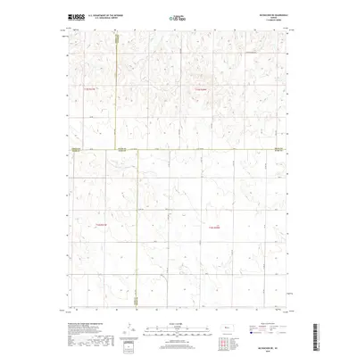
2018 Map of McCracken NE
USGS Topo · Published 2018About this map
Snake Cr meanders through this portion of the High Plains where the borders of Ellis, Ness, Trego, and Rush counties converge. This 2018 survey documents a strictly ordered landscape of section lines and gravel roads that define the rural character of the region. The map reveals the precise intersection of several county boundaries, including the Trego Co Ellis Co and Ellis Co Rush Co lines, reflecting the grid-based development of Kansas agriculture. Named thoroughfares like Chetolah Gold Rd and S Co Line Rd provide the primary framework for local travel between family farmsteads. The terrain is marked by gentle undulations and seasonal drainage patterns typical of the western Kansas landscape, where water features like Snake Cr are central to the geography of the local townships.
Find a feature on this map
32 named features on this map. Tap any name to fly to it.
Don’t see what you’re looking for? This feature index may not catch every label — zoom into the map to look around manually.
Map Details
Editions of this 2018 McCracken NE Map
This is the sole edition of this map. No revisions or reprints were ever made.
Other maps of this area

1893 · Ellis
USGS Topo · 1:125,000

1896 · Hays
USGS Topo · 1:125,000

1955 · Great Bend
USGS Topo · 1:250,000

1957 · Great Bend
USGS Topo · 1:250,000

1958 · Great Bend
USGS Topo · 1:250,000

1961 · Antonino
USGS Topo · 1:24,000

1965 · Mc Cracken
USGS Topo · 1:24,000

1966 · Mc Cracken SW
USGS Topo · 1:24,000

1966 · Hargrave
USGS Topo · 1:24,000
1968 · La Crosse NW
USGS Topo · 1:24,000