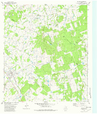
1982 Map of McDade
USGS Topo · Published 1982About this map
The town of Mc Dade sits at the southwestern edge of this landscape, anchored by the Southern Pacific railroad line that cuts through the Bastrop and Lee County borderlands. The terrain is defined by the prominent Yegua Knobbs and a dense network of watercourses including West Yegua Creek and Gum Spring Branch. This 1980s-era study reveals a rural Texas landscape heavily marked by family and community history, evidenced by a high concentration of cemeteries such as New Knobbs Springs Cem, Old Knobbs Springs Cem, and Bachman Cem. The southern portion of the map includes the edge of the Camp Swift Mil Res, while industrial activity is noted through scattered gravel pits and an unnamed Mine. Small community centers like The Knobbs and local landmarks such as St Andrews Ch provide specific points of interest for genealogists tracing ancestral homesteads in these wooded creek bottoms.
Find a feature on this map
34 named features on this map. Tap any name to fly to it.
Don’t see what you’re looking for? This feature index may not catch every label — zoom into the map to look around manually.
Map Details
Editions of this 1982 McDade Map
This is the sole edition of this map. No revisions or reprints were ever made.
Other maps of this area

1885 · Bastrop
USGS Topo · 1:125,000

1893 · Bastrop
USGS Topo · 1:125,000

1904 · Bastrop
USGS Topo · 1:125,000

1948 · Smithville
USGS Topo · 1:62,500

1948 · Elgin
USGS Topo · 1:62,500

1948 · Bastrop
USGS Topo · 1:62,500

1948 · Lexington
USGS Topo · 1:62,500

1950 · Lexington
USGS Topo · 1:62,500

1950 · Bastrop
USGS Topo · 1:62,500

1950 · Smithville
USGS Topo · 1:62,500