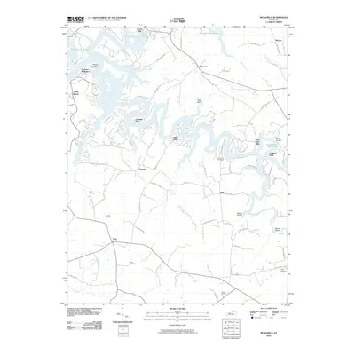
2010 Map of McDaniels
USGS Topo · Published 2010About this map
The sprawling waters of the Rough River Reservoir dominate this landscape, creating a complex shoreline of inlets and points such as Cannons Point and Indian Valley. This 2010 survey illustrates the rural character of the region, where older crossroads settlements and family landmarks persist alongside the recreational geography of the reservoir. Communities like McDaniels, Duff, and Hinton Hills are connected by a network of winding local roads, including Holiday Beach Rd and Camp Green Shores Rd.
Find a feature on this map
81 named features on this map. Tap any name to fly to it.
Don’t see what you’re looking for? This feature index may not catch every label — zoom into the map to look around manually.
Map Details
Editions of this 2010 McDaniels Map
This is the sole edition of this map. No revisions or reprints were ever made.
Other maps of this area

1922 · Leitchfield
USGS Topo · 1:48,000

1925 · Spring Lick
USGS Topo · 1:62,500

1925 · Leitchfield
USGS Topo · 1:62,500

1932 · Fordsville
USGS Topo · 1:62,500

1953 · Custer
USGS Topo · 1:24,000

1953 · Mc Daniels
USGS Topo · 1:24,000

1953 · Kingswood
USGS Topo · 1:24,000

1953 · Falls Of Rough
USGS Topo · 1:24,000
1953 · Glen Dean
USGS Topo · 1:24,000

1954 · Evansville
USGS Topo · 1:250,000