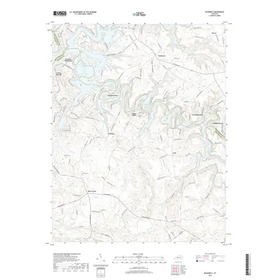
2019 Map of McDaniels
USGS Topo · Published 2019About this map
Rough River Lake dominates the northern landscape of this region, its winding fingers creating a complex shoreline that shapes the local road network and settlements like Cannons Point and Indian Valley. This 2019 survey documents a rural Kentucky environment where small communities and historical family markers are preserved alongside modern recreation. Notable for genealogists, the map identifies numerous family burial grounds including Shain Cem, Poole Cem, and Thomason Cem. The settlement at Horn Back Mill and the prominent Cobblers Knob sit near the county line, while the drainage of Short Cr and Isaac Fork define the southern topography. The transition from the lakefront leisure areas to the inland farming communities of Duff and Concord illustrates the dual nature of modern Breckinridge County.
Find a feature on this map
113 named features on this map. Tap any name to fly to it.
Don’t see what you’re looking for? This feature index may not catch every label — zoom into the map to look around manually.
Map Details
Editions of this 2019 McDaniels Map
This is the sole edition of this map. No revisions or reprints were ever made.
Other maps of this area

1922 · Leitchfield
USGS Topo · 1:48,000

1925 · Spring Lick
USGS Topo · 1:62,500

1925 · Leitchfield
USGS Topo · 1:62,500

1932 · Fordsville
USGS Topo · 1:62,500

1953 · Custer
USGS Topo · 1:24,000

1953 · Mc Daniels
USGS Topo · 1:24,000

1953 · Kingswood
USGS Topo · 1:24,000

1953 · Falls Of Rough
USGS Topo · 1:24,000
1953 · Glen Dean
USGS Topo · 1:24,000

1954 · Evansville
USGS Topo · 1:250,000