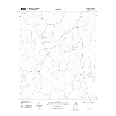
2012 Map of McDonald
USGS Topo · Published 2012About this map
The Neshoba County Fairgrounds sit at the heart of this rural landscape near Coldwater, reflecting the deep-rooted social traditions of Neshoba County. This 2012 survey illustrates a network of small, scattered communities like Dixon and Linwood, connected by a complex grid of county roads. The terrain is defined by a system of water management, including the Lonsilocher Canal and Fulton Canal, which channel water through the agricultural lands toward the Pearl River basin. The map is particularly useful for genealogists, as it meticulously identifies numerous local burial sites such as Mount Carmel Cem, Hope Cem, and Morrow Memorial Cem. The settlement pattern at McDonald and the surrounding hamlets indicates a region still primarily organized around agricultural production and community gathering points.
Find a feature on this map
97 named features on this map. Tap any name to fly to it.
Don’t see what you’re looking for? This feature index may not catch every label — zoom into the map to look around manually.
Map Details
Editions of this 2012 McDonald Map
This is the sole edition of this map. No revisions or reprints were ever made.
Other maps of this area

1953 · Meridian
USGS Topo · 1:250,000

1957 · Meridian
USGS Topo · 1:250,000

1962 · Edinburg
USGS Topo · 1:62,500

1965 · Meridian
USGS Topo · 1:250,000

1972 · Pearl River
USGS Topo · 1:24,000

1972 · Deemer
USGS Topo · 1:24,000

1972 · Union East
USGS Topo · 1:24,000
1972 · Philadelphia
USGS Topo · 1:24,000

1972 · Madden
USGS Topo · 1:24,000
1972 · Sebastopol
USGS Topo · 1:24,000