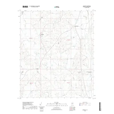
2018 Map of McDonald
USGS Topo · Published 2018About this map
McDonald and Dixon anchor this section of Neshoba County, where the landscape is defined by the headwaters of Beasha Creek and a network of agricultural drainage canals. The map illustrates a rural settlement pattern centered on crossroads communities such as Good Hope, Trapp, and Coldwater, each connected by a winding grid of county roads. Genealogical interest is high throughout the area, with several established burial sites including Morrow Memorial Cem, Mount Carmel Cem, and Dixon Cem serving as local landmarks. The eastern edge of the quadrangle shows the engineered waterways of Lonsilocher Canal and Fulton Canal, which transition the terrain toward the Pearl River basin. This 2018 update of the Pearl River vicinity maintains the record of these small communities and their historic cemeteries, which remain central to the region’s local identity and heritage.
Find a feature on this map
83 named features on this map. Tap any name to fly to it.
Don’t see what you’re looking for? This feature index may not catch every label — zoom into the map to look around manually.
Map Details
Editions of this 2018 McDonald Map
This is the sole edition of this map. No revisions or reprints were ever made.
Other maps of this area

1953 · Meridian
USGS Topo · 1:250,000

1957 · Meridian
USGS Topo · 1:250,000

1962 · Edinburg
USGS Topo · 1:62,500

1965 · Meridian
USGS Topo · 1:250,000

1972 · Pearl River
USGS Topo · 1:24,000

1972 · Deemer
USGS Topo · 1:24,000

1972 · Union East
USGS Topo · 1:24,000
1972 · Philadelphia
USGS Topo · 1:24,000

1972 · Madden
USGS Topo · 1:24,000
1972 · Sebastopol
USGS Topo · 1:24,000