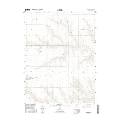
2015 Map of McDonald
USGS Topo · Published 2015About this map
McDonald anchors this High Plains landscape, situated along the southern edge of the quadrangle where the town grid is clearly defined by Rawlins Ave and N Railway St. The surrounding terrain is deeply incised by the drainage systems of N Beaver Cr and Little Beaver Cr, creating a complex network of draws and ridges that stand in contrast to the flat upland sections. Aviation history is noted on the prairie with the presence of Black Airport and Jack Poore Airport, while the section lines are defined by a regular grid of rural roads like RD V and RD A. This survey captures the specialized land use of Rawlins County, showing how small-town life and local aviation integrated with the agricultural rhythm of the western Kansas plains.
Find a feature on this map
21 named features on this map. Tap any name to fly to it.
Don’t see what you’re looking for? This feature index may not catch every label — zoom into the map to look around manually.
Map Details
Editions of this 2015 McDonald Map
This is the sole edition of this map. No revisions or reprints were ever made.
Other maps of this area

1950 · Mc Donald
USGS Topo · 1:62,500

1951 · Mc Donald
USGS Topo · 1:62,500

1951 · Atwood
USGS Topo · 1:62,500

1951 · Chardon
USGS Topo · 1:62,500

1951 · Dewey Ranch
USGS Topo · 1:62,500

1954 · Goodland
USGS Topo · 1:250,000

1956 · Goodland
USGS Topo · 1:250,000

1957 · Goodland
USGS Topo · 1:250,000
1978 · Beardsley
USGS Topo · 1:24,000
1978 · Mc Donald NW
USGS Topo · 1:24,000